Diamond Head
The unique profile of Diamond Head (Lē‘ahi) sits prominently near the eastern edge of Waikiki’s coastline. Hawai’i’s most recognized landmark is known for its historic hiking trail, stunning coastal views, and military history. Diamond Head State Monument encompasses over 475 acres, including the interior and outer slopes of the crater.
Formation
The creation of the island of Oahu began around 2.5 to 4 million years ago with the volcanic eruption from two shield volcanoes. Lēʻahi (later known as Diamond Head) is believed to have been formed about 300,000 years ago during a single brief eruption. With strong winds the subsequent magma and ash fused together leaving behind several tuff cones around Oahu. Time, erosion, and weathering would shape the cones into their current recognizable shapes: Koko Head, Punchbowl, Hanauma Bay, and Lēʻahi.
Early History
Lēʻahi received its name from Native Hawaiians due to the peak’s resemblance to the brow/forehead (lae) of a tuna (ʻahi). According to legend, this name was given to the crater by Hi‘iaka, sister of the fire goddess Pele. Another translation is “fire headland” and refers to the navigational fires that were lit at the summit to assist canoes traveling along the shoreline.
At the turn of the century, British explorers and traders believed that the calcite crystals discovered around the crater’s slopes and beaches were diamonds. Lēʻahi was then briefly referred to as Kaimana Hila (Diamond Hill) before receiving the name Diamond Head. In 1904 the United States Government would purchase the crater and surrounding area, roughly 720 acres, for $3,300. With the adjustment of inflation this sum would be around roughly $115,376.63 in 2023. The United States would designate the site for military use and would begin fortification in 1908.
In 1917 construction began to rebuild the Diamond Head Lighthouse located along the shoreline of Diamond Head Beach Park. The original structure had been erected in 1899 after two ships ran aground in 1897. Due to cracks in the concrete foundation, the 1899 lighthouse would be demolished and rebuilt. The lighthouse is 147 ft (44.80 meters) above sea level & its actual height is 55 ft (over 16 meters). In 1932 the U.S. Coast Guard assumed responsibility for maintaining this Aid to Navigation. (US Coast Guard - PacArea).

Military History
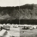
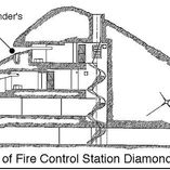
Fort Ruger and Fort DeRussy (on the west end of what is now Waikiki) would comprise the Army Coastal Artillery defense system on the Island of O’ahu. Diamond Head’s summit would be utilized as the primary coastal defense point for the eastern end of the Island. In 1908 a fire control station, gun emplacements, a north wall entrance tunnel (Kapahulu Tunnel), and batteries would be constructed in and around the crater. It was during this time that a dirt trail was completed to ensure foot and/or mule traffic to and from the summit. Ultimately the goal was to utilize Diamond Head’s summit and tunnel systems to protect Honolulu from both ground and sea invasion.
According to Hawaii.gov, Diamond Head would receive a total of five batteries throughout its history. These would include, Harlow (1910) on the northern exterior, Dodge and Hulings (1913) which tunnel through the eastern crater wall, Birkhimer (1916) which is largely below ground inside the crater, and Battery 407 (1943) which tunnels through the southern wall of the crater and faces seaward. Battery Harlow and Birkhimer were positioned inside the crater to fire south towards enemy ships. Various guns were stationed within Diamond Head to ensure a 360 degree field of fire and a range to fire over the Koolau Mountains to the north and reach Kaneohe Bay (DiamondHeadHike.org).
Diamond Head would continue to receive sporadic adjustments and modifications throughout the early 1900s. These efforts increased after the First World War to ensure the guns and batteries were properly camouflaged and protected from potential air strikes.

World War II
On December 7th, 1941 Japan launched a surprise attack on the Island of O’ahu. As a result, several military sites around the Island were severely affected. Although Diamond Head was not targeted by the Japanese, it would play a pivotal role in the Island’s defense during the Second World War. The summit would once again be utilized as a military lookout post.
Construction for Battery 407 began in 1943 and would be completed in 1944. It was fitted with “gas-proof” tunnels to protect occupants from chemical warfare. The Battery was initially meant to hold several guns salvaged from the USS Arizona. While the mounts for the guns were prepared, the guns themselves were never installed. The USS Arizona’s guns had been badly damaged during the attack and replacement parts were difficult to source. None of the guns around Diamond Head were ever fired during World War II. Today, Battery 407 is used by the Hawaii National Guard.
Additionally, the excavation and construction of the Kahala Tunnel was completed during this time. The Kahala Tunnel is positioned on the east side of the crater and is used as the primary entrance for State Park visitors to this day. It is wider than the Kapahulu Tunnel, to ensure larger vehicles could access the crater, and fitted with iron gates to both seal the crater and protect it from falling rocks.

Today
In 1968, Diamond Head was designated as a national natural landmark.
With the state monument encompassing over 475 acres, Diamond Head is credited as being one of the most recognizable landmarks in Hawaii. With the summit offering 360-degree views of Oahu, it is a popular hiking destination for residents and visitors alike. The 0.8 mile hike from the trailhead to the summit is steep and strenuous, gaining 560 feet as it ascends from the crater floor (Hawaii.gov). In total the hike is 1.6 miles roundtrip. Portions of the trail have been paved to ensure guest safety. Access to the summit’s original fire control station is still open to the public as an observation point. From the top of the 82-step metal staircase, bunkers and the 1917 Diamond Head Lighthouse can be seen.


